Dibuja ARC Polyline en Google Map
¿Cómo puedo dibujar Arc Polyline en Google Map?
Ya uséesta código para crearcurvo Polilínea.
Aquí está elmétodo para dibujar polilínea curvada:
private void showCurvedPolyline (LatLng p1, LatLng p2, double k) {
    //Calculate distance and heading between two points
    double d = SphericalUtil.computeDistanceBetween(p1,p2);
    double h = SphericalUtil.computeHeading(p1, p2);

    //Midpoint position
    LatLng p = SphericalUtil.computeOffset(p1, d*0.5, h);

    //Apply some mathematics to calculate position of the circle center
    double x = (1-k*k)*d*0.5/(2*k);
    double r = (1+k*k)*d*0.5/(2*k);

    LatLng c = SphericalUtil.computeOffset(p, x, h + 90.0);

    //Polyline options
    PolylineOptions options = new PolylineOptions();
    List<PatternItem> pattern = Arrays.<PatternItem>asList(new Dash(30), new Gap(20));

    //Calculate heading between circle center and two points
    double h1 = SphericalUtil.computeHeading(c, p1);
    double h2 = SphericalUtil.computeHeading(c, p2);

    //Calculate positions of points on circle border and add them to polyline options
    int numpoints = 100;
    double step = (h2 -h1) / numpoints;

    for (int i=0; i < numpoints; i++) {
        LatLng pi = SphericalUtil.computeOffset(c, r, h1 + i * step);
        options.add(pi);
    }

    //Draw polyline
    mMap.addPolyline(options.width(10).color(Color.MAGENTA).geodesic(false).pattern(pattern));
}
SALIDA
1. Si estoy usando this.showCurvedPolyline (latLng1, latLng2, 0.1); luego obteniendo:
Como puede ver en la imagen de arriba, estamos muy cerca de alcanzar nuestro objetivo, pero no sabemos por qué no se conecta con otro punto final
2. Si estoy usando this.showCurvedPolyline (latLng1, latLng2, 1); luego obteniendo: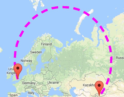
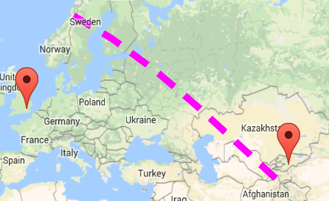
Nota: No quiero tantoforma de círculo grande, De VerdadNo quiero tantoaltura.
Aquí esta lo queQuiero una forma de arco como se muestra en la imagen de abajo

Aquí está elCÓDIGO Estoy usando paraagregar polilínea curva entre dosgeo-locatios :
private void addCurvedPolyLine() {

        LatLng latLng1 = new LatLng(40.7128, 74.0059); // New York
        LatLng latLng2 = new LatLng(51.5074, 0.1278); // London

        Marker marker1 = mMap.addMarker(new MarkerOptions().position(latLng1).title("Start"));
        Marker marker2 = mMap.addMarker(new MarkerOptions().position(latLng2).title("End"));

        LatLngBounds.Builder builder = new LatLngBounds.Builder();

        builder.include(marker1.getPosition());
        builder.include(marker2.getPosition());

        LatLngBounds bounds = builder.build();
        int padding = 0; // offset from edges of the map in pixels
        CameraUpdate cu = CameraUpdateFactory.newLatLngBounds(bounds, padding);
        mMap.moveCamera(cu);
        mMap.animateCamera(cu);

        this.showCurvedPolyline(latLng1, latLng2, 0.1);

    }