Agrupar datos en una cuadrícula hexagonal en Google Maps
Estoy tratando de mostrar datos geoespaciales en una cuadrícula hexagonal en un mapa de Google.
Para hacerlo, dado un tamaño de cuadrícula de mosaico hexagonalX Necesito poder convertir ({lat, lng}) coordina en el ({lat, lng}) centros de las cuadrículas de hexágono que los contienen.
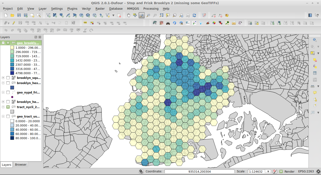
Al final, me gustaría poder mostrar datos en un mapa de Google como este:
¿Alguien tiene alguna idea de cómo se hace esto?
He intentado portar este script de agrupación de hexágonos de Python,binner.py a Javascript pero no parece funcionar correctamente, los valores de salida son todos los mismos que los de entrada.
Por el bien de este ejemplo, no me importa si hay múltiples polígonos en una sola ubicación, solo necesito descubrir cómo agruparlos en las coordenadas correctas.
Código a continuación, (¡Plunker aquí!)
var map;
var pointCount = 0;
var locations = [];
var gridWidth = 200000; // hex tile size in meters
var bounds;

var places = [
  [44.13, -69.51],
  [45.23, -67.42],
  [46.33, -66.53],
  [44.43, -65.24],
  [46.53, -64.15],
  [44.63, -63.06],
  [44.73, -62.17],
  [43.83, -63.28],
  [44.93, -64.39],
  [44.13, -65.41],
  [41.23, -66.52],
  [44.33, -67.63],
  [42.43, -68.74],
  [44.53, -69.65],
  [40.63, -70.97],
]

var SQRT3 = 1.73205080756887729352744634150587236;

$(document).ready(function(){

  bounds = new google.maps.LatLngBounds();

  map = new google.maps.Map(document.getElementById("map_canvas"), {center: {lat: 0, lng: 0}, zoom: 2});

  // Adding a marker just so we can visualize where the actual data points are.
  // In the end, we want to see the hex tile that contain them
  places.forEach(function(place, p){

    latlng = new google.maps.LatLng({lat: place[0], lng: place[1]});
    marker = new google.maps.Marker({position: latlng, map: map})

    // Fitting to bounds so the map is zoomed to the right place
    bounds.extend(latlng);
  });

  map.fitBounds(bounds);

  // Now, we draw our hexagons! (or try to)
  locations = makeBins(places);

  locations.forEach(function(place, p){
    drawHorizontalHexagon(map, place, gridWidth);
  })


});


  function drawHorizontalHexagon(map,position,radius){
    var coordinates = [];
    for(var angle= 0;angle < 360; angle+=60) {
       coordinates.push(google.maps.geometry.spherical.computeOffset(position, radius, angle));
    }

    // Construct the polygon.
    var polygon = new google.maps.Polygon({
        paths: coordinates,
        position: position,
        strokeColor: '#FF0000',
        strokeOpacity: 0.8,
        strokeWeight: 2,
        fillColor: '#FF0000',
        fillOpacity: 0.35,
        geodesic: true
    });
    polygon.setMap(map);
}

// Below is my attempt at porting binner.py to Javascript.
// Source: https://github.com/coryfoo/hexbins/blob/master/hexbin/binner.py

function distance(x1, y1, x2, y2){
  console.log(x1, y1, x2, y2);
  result =  Math.sqrt(((x1 - x2) * (x1 - x2)) + ((y1 - y2) * (y1 - y2)));
  console.log("Distance: ", result);
  return result;
}

function nearestCenterPoint(value, scale){
    div = (value / (scale / 2));
    mod = value % (scale / 2);

    if(div % 2 == 1){
      increment = 1;
    } else {
      increment = 0;
    }

    rounded = (scale / 2) * (div + increment);

    if(div % 2 === 0){
      increment = 1;
    } else {
      increment = 0;
    }

    rounded_scaled = (scale / 2) * (div + increment)
    result = [rounded, rounded_scaled];

    return result;
}

function makeBins(data){
  bins = [];

  data.forEach(function(place, p){
    x = place[0];
    y = place[1];

    console.log("Original location:", x, y);

    px_nearest = nearestCenterPoint(x, gridWidth);

    py_nearest = nearestCenterPoint(y, gridWidth * SQRT3);

    z1 = distance(x, y, px_nearest[0], py_nearest[0]);

    z2 = distance(x, y, px_nearest[1], py_nearest[1]);

    console.log(z1, z2);

    if(z1 > z2){
      bin = new google.maps.LatLng({lat: px_nearest[0], lng: py_nearest[0]});
       console.log("Final location:", px_nearest[0], py_nearest[0]);
    } else {
      bin = new google.maps.LatLng({lat: px_nearest[1], lng: py_nearest[1]});
       console.log("Final location:", px_nearest[1], py_nearest[1]);
    }

    bins.push(bin);

  })
  return bins;
}